Top 5 Forestry Drones in the United States for Sustainable Practices, 2025
Published on Saturday, March 29, 2025
Forestry drones are specialized UAVs engineered to enhance efforts in reforestation and wildlife monitoring by delivering high-quality aerial imagery and data collection. As USA becomes increasingly focused on sustainability and environmental protection, the appeal of these drones in the market has surged. With the ability to monitor vast forested areas quickly and accurately, forestry drones are not just a technological advancement but a vital tool for ecologists, conservationists, and resource managers alike. Their efficiency in assessing forest health and managing resources sets them apart as an essential innovation in modern forestry practices.
Top Picks Summary
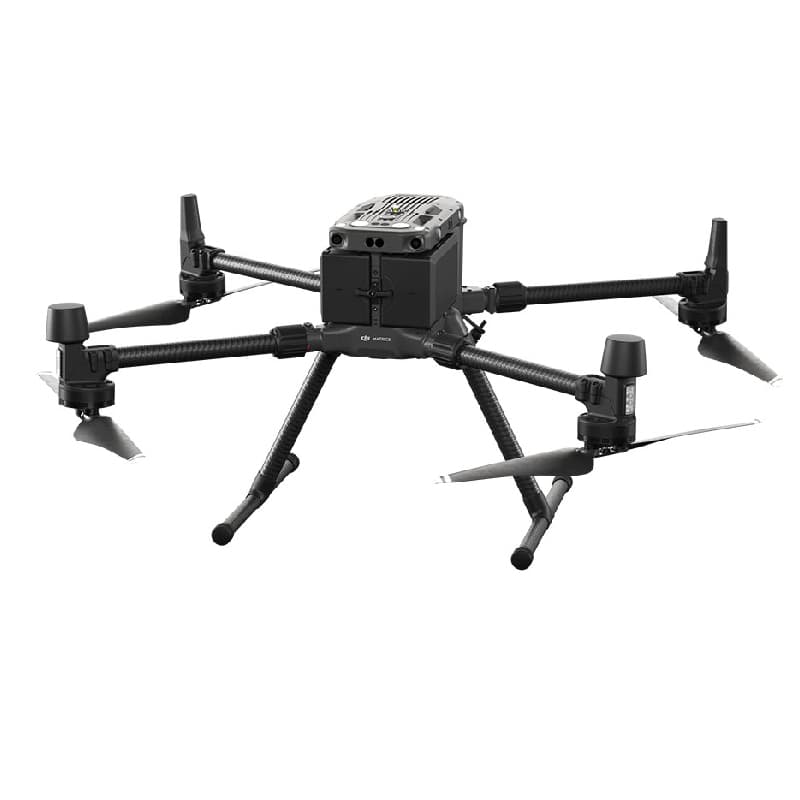
DJI Matrice 300 RTK
The DJI Matrice 300 RTK is a cutting-edge commercial drone that combines AI capabilities with a robust flight design. Recognized for its advanced features like obstacle avoidance and intelligent flight modes, it delivers precision mapping and data collection for various industries. Its versatility is further enhanced by its ability to integrate with multiple payloads, making it suitable for surveying, inspection, and public safety. With a flight time of up to 55 minutes, it is a top choice for professionals seeking efficiency and superior performance.
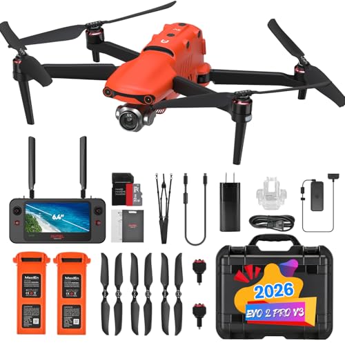
Autel Robotics EVO II Pro
The Autel Robotics EVO II Pro stands out with its impressive 6K video resolution and the ability to operate in low-light conditions, making it ideal for aerial photography and videography. Its modular design allows for quick swapping of camera modules, further enhancing its adaptability for various professional applications. The drone features a robust flight time of up to 40 minutes and advanced obstacle avoidance systems, making it a favored option amongst creative professionals. With its user-friendly interface, it caters to both seasoned pilots and newcomers.
DJI Mavic 3 Enterprise
The DJI Mavic 3 Enterprise excels in the commercial drone sector with its dual-camera system, featuring a wide-angle lens and a 3-axis gimbal for unparalleled stability. Known for its high-resolution imagery, it is specifically designed for inspection and surveying tasks, making it a vital tool for businesses. The drone offers up to 45 minutes of flight time and boasts enhanced safety features that ensure safe operation in complex environments. Its rugged design and portability perfectly balance durability with functionality, appealing to a diverse range of professional users.

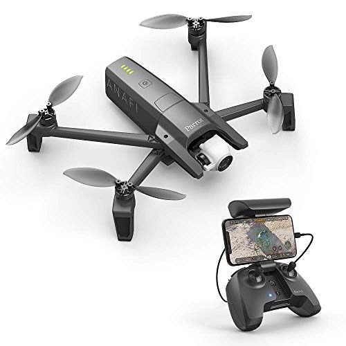
Parrot Anafi USA
The Parrot Anafi USA is making waves in the industry with its impressive capabilities designed specifically for first responders and security professionals. Its unique 32x zoom capability and thermal imaging ensure it provides valuable insights in critical situations. With a flight time of 32 minutes and rugged design, it operates effectively in various weather conditions. The drone's compact size makes it highly portable and easy to deploy, offering agencies a reliable solution for emergency and reconnaissance missions.
Skydio X2
The Skydio X2 is renowned for its unmatched autonomous navigating ability powered by advanced AI technology. It delivers exceptional obstacle avoidance and tracking capabilities, making it perfect for drone operations in dynamic environments. With a robust flight time of approximately 35 minutes and a modular design, it adapts easily to a variety of commercial applications. Its focus on safety and user-friendliness positions it as a leading choice for industries looking to streamline workflows and enhance operational efficiency.

Forestry drones offer robust flight capabilities and specialized sensors to monitor vegetation health, optimize resource allocation, and assist in sustainable land management.
Understanding the Benefits of Forestry Drones
Forestry drones represent a groundbreaking approach in maintaining and monitoring forest ecosystems. They combine technology with environmental stewardship, making them indispensable tools for today's ecologists and resource managers.
Enhanced Monitoring: Forestry drones can cover large areas in a fraction of the time compared to traditional surveying methods, allowing for more comprehensive mapping and monitoring of forests.
Data-Driven Decisions: High-resolution imagery collected by drones provides valuable data that informs sustainable forestry practices and helps in making crucial management decisions.
Cost-Effective Solutions: Using drones reduces the need for extensive manpower and equipment, significantly lowering the costs associated with forest assessments.
Improved Reforestation Efforts: Drones can identify areas in need of reforestation and streamline planting efforts, which is essential for maintaining biodiversity.
Wildlife Protection: Equipped with thermal imaging, drones can monitor wildlife populations and habitats, aiding in the protection of endangered species.
Research and Development: Ongoing scientific studies demonstrate the effectiveness of drones in forest management, showcasing their ability to improve yield and reduce ecological footprints.
Frequently Asked Questions
Which drone should I buy for forest mapping tasks?
Choose the DJI Matrice 300 RTK: it’s designed for industrial applications with advanced AI capabilities and has 30 minutes of flight time, plus an average rating of 4.7.
Does Autel Robotics EVO II Pro have long-range transmission?
Yes—Autel Robotics EVO II Pro lists “Long-range transmission” as a key feature, and it also offers 4K video resolution with an average rating of 4.5.
Is DJI Matrice 300 RTK worth it compared to Autel EVO II Pro?
DJI Matrice 300 RTK doesn’t show a listingPrice here, while Autel Robotics EVO II Pro is $2,099.00 USDand provides 4K video resolution plus long-range transmission.
How do DJI Mavic 3 Enterprise thermal imaging and warranty?
DJI Mavic 3 Enterprise supports thermal imaging capabilities with an average rating of 4.6, but no warranty duration is provided in the data.
Conclusion
In conclusion, the importance of forestry drones in the USA is growing as we strive for more sustainable forest management and conservation practices. We hope you found the information valuable and encourage you to use the search bar for any specific inquiries or further details.