Top 4 Mapping Drones in the United States for 2025: Unleash Aerial Precision
Published on Saturday, March 29, 2025
Mapping drones are essential tools for creating accurate geographical maps and models. They utilize advanced technology to collect data and generate stunning aerial maps, which are indispensable for urban planning, environmental monitoring, land surveying, and much more. With the increasing demand for accurate mapping in diverse sectors like agriculture, real estate, and disaster management, American consumers are turning to these sophisticated aerial devices to better understand and manage their environments. This growing trend reflects a shift towards incorporating drone technology into everyday utilities, as public awareness and usability continue to evolve.
Top Picks Summary
The Microdrones mdMapper3000DuoG VHR is an advanced mapping solution renowned for its high-resolution data collection. Combining drone technology with innovative mapping software, it offers seamless integration for surveying and infrastructure projects. The mdMapper3000DuoG VHR stands out for its precision and speed, enabling professionals to gain rapid insights from their data. Its versatility in various applications makes it a prime choice for surveyors and engineers.

The Autel EVO II Pro V3 stands out as a value leader for high-resolution visual environmental mapping, delivering a large-sensor camera and long flight time at a lower price point than comparable flagship models. For projects prioritizing imagery quality and budget, it offers a financially attractive middle ground—providing better raw imaging performance and flight endurance than consumer multispectral units while avoiding the higher integration and lifecycle costs of heavy-enterprise platforms.

The SenseFly eBee X is a market leader known for its impressive endurance and flexible payload options. This fixed-wing drone excels in mapping and surveying tasks, enabling users to cover large areas quickly and efficiently. Its advanced software suite offers seamless integration with existing workflows, enhancing productivity and accuracy. The eBee X’s robust design ensures reliable performance in various weather conditions, making it a trusted choice for professionals worldwide.
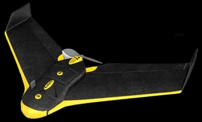
10,000-15,000$
The Skydio 2+ is recognized for its advanced autonomous flying technology that allows it to navigate complex environments with minimal user input. With an impressive 4K60 video capture capability and real-time obstacle avoidance, it excels in active tracking and filming dynamic subjects. Its AI-driven capabilities set it apart from traditional drones, making it an ideal choice for creative professionals and organizations needing high-quality aerial footage. Skydio's commitment to innovation and user-friendly experience positions it as a leader in the market.

1200-1500$
What makes mapping drones the best in their category? Their integration of GIS capabilities and high-fidelity imaging allows for precise mapping that meets professional standards.
Understanding the Benefits of Mapping Drones
Mapping drones are revolutionizing how we survey geographical landscapes by delivering precise and efficient mapping solutions.
Advanced GPS technology ensures high levels of accuracy in mapping outcomes for urban and rural environments.
Drones can cover large areas quickly compared to traditional survey methods, saving time and resources.
The integration of thermal and multispectral sensors allows for detailed analysis across various sectors such as agriculture.
Real-time data capture enables quick decision-making, particularly important in disaster management and emergency services.
User-friendly interfaces make it easier for various stakeholders beyond technical experts to utilize mapping drones.
Enhanced visualization through 3D mapping supports better planning and communication of projects across local communities.
Frequently Asked Questions
Which mapping drone should I buy for surveying projects?
Choose the Microdrones mdMapper3000DuoG VHR for surveying and complex projects, since it has dual-sensor integration and an average rating of 4.8.
Does the DJI Matrice 300 RTK offer long flight time?
Yes—the DJI Matrice 300 RTK supports exceptional flight time up to 55 minutes and has an average rating of 4.8.
How does pricing compare between these mapping drones?
Price details aren’t provided for Microdrones mdMapper3000DuoG VHR, DJI Matrice 300 RTK, or Autel EVO II Pro Enterprise, so I can’t compare exact costs from the available data.
Is the Autel EVO II Pro Enterprise good for thermal mapping?
Yes—Autel EVO II Pro Enterprise includes thermal imaging and a zoom camera, with an average rating of 4.7.
Conclusion
In summary, the emergence of mapping drones in the United States, supported by their multifaceted benefits, marks a notable advancement in geographical data collection and analysis. We hope you found the information you were looking for. If you have more specific queries or need detailed insights, please use the search bar.